Monday, October 21, 2019

Colorado's Western Slope

An Outdoorsman Mecca

Fruita is a place like no other. With beautiful landscapes, a wide variety of recreation for all seasons, Fruita is truly a unique place to spend time in.

We try to spend a few days in Fruita every time we pass through. The Kokopelli Trail and Fruita North Desert have been our go to for mountain biking and hiking in the past.  With so much to offer, we had to try some other trails.
Fruita is a paradise for outdoor-lovers with many activities to choose from. The arid climate means that winters are short and mild, so spring and fall are great times to get outside with world-class mountain biking for all abilities, hiking trails with stunning views, the Colorado River and its rafting.

The area reminds us of Sedona or Moab without the crowds.
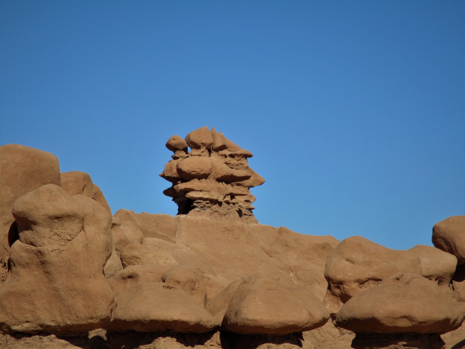
McInnis Canyons National Conservation Area is a public land space located just outside of Fruita. This conservation area is home to the second largest concentration of natural arches in the United States, as well as home to a 25-mile stretch of the Colorado River. With a variety of trails, McInnis Canyon offers great views for everyone, no matter how far you hike.
We took the Devil's Canyon Loop Trail, a 6.7 mile heavily trafficked loop trail and is rated as moderate. The further we hiked, the more amazing the scenery.

We entered the Black Ridge Canyon Wilderness area as we hiked further into the Devil's Canyon.
There is almost an endless number of trail combinations in this area. There are trails that lead to Kodels Canyon, one that takes you to Flume Canyon and many different routes around the Devils Canyon area. We appreciate our Hiking Project app to help us see where we were and wanted to go
with all of the options available to us. Fortunately, the trails were well marked.

Colorado Monument

The Colorado Monument is high above Fruita on the plateau, connecting to Grand Junction. From the visitor's Center next to the campground the road continues to climb opening up to some amazing views.

The pullouts along the Monument were a good place for rest stops disguised as photo ops.

While riding the bike path along the Colorado River, we met a couple of local ladies that recommended the Hot Tomato for salad and pizza considered to be the go to for cyclists. We had to say that they were right about the hole in the wall we almost missed.
We hiked through Dinosaur Hill to explore dinosaur history. During the mile-long trail, you can stop at 10 different points of interest for dinosaur bones, informational plaques, and great scenery.

Palisade, Colorado

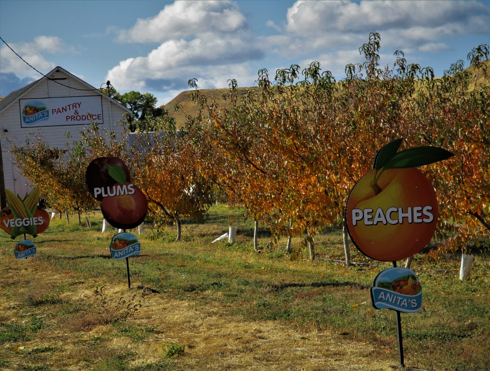
We always miss the Palisade Tour de Vineyards bike ride through the orchards and vineyards every mid September. We arrived the middle of October and rode the well marked route on our own and loved it. There happened to be a pie store on the route which meant a peach empanada was in order. Palisade is known for its fabulous peaches.
Grand Junction has a great paved trail system with over 30 miles along the rivers extending to Palisades to the east and Fruita to the west. We ended up cycling more than hiking this stay.


We stopped in Palisade's Fall market and filled our little bag with peaches pears and the last of the mouth watering tomatoes (I am going to miss them this winter) while we listened to a pretty good band playing in the park. It definitely feels like fall.

This is the wine region of Colorado's western slope so of course we made a stop at a winery. Every thing was on sale 25-40% off since the season is winding down. 
It has been a treat to be here since we are usually in Arizona this time of year. The winds have been rocking us awake at night as we plan which day would be the best to avoid the snow and get over Vail Pass.
It has been a great trip from Oregon. But I am missing Kyle and Tyler and am ready for a couple of  big hugs.

Tuesday, October 15, 2019

Capitol Reef NP and Goblin Valley in Utah

Down Some Red Dirt Roads

We found our selves in the middle of the annual southward migration of the grey haired Snowbirds as we arrived at the KOA north of Salt Lake City on our way to Central Utah. There doesn't seem to be any danger of extinction any time soon. Mike built a fire in the community fire ring which signaled to the birds to come out of their mobile nests for some sharing before settling in for the night.
We woke to a temperature of 15 degrees in Torrey, Utah outside of Capitol Reef National Park. Fortunately, nothing in the trailer froze and we were snug and warm until someone (Mike) had to get up in the morning and turn up the heat. The campground water tap was frozen. But our pipes were fine.

The dry camping campground nestled in the Fruita section along the Fremont River in the national park was booked up which was fine with me since it was so cold and our little heater could run all night. Sand Creek Campground in Torrey was only 5 miles from the national park.

Our last visit to Capitol Reef National Park was 10 years ago. It doesn't matter how many times we visit the red rocks of southern Utah and Arizona, we always are glad to be back.
Located in south-central Utah in the heart of red rock country, Capitol Reef National Park is a hidden treasure filled with cliffs, canyons, domes, and bridges in the Waterpocket Fold (a wrinkle on the earth) extending almost 100 miles.

The most scenic portion of the Waterpocket Fold is known as Capitol Reef: capitol for the white domes of Navajo Sandstone that resemble capitol building domes and reef for the rocky cliffs which are a barrier to travel, like a coral reef.
It was a chilly 40 degrees as we started hiking each morning. It didn't take long, once we started climbing in the sunshine to start shedding layers.


The Castle
A nearly 100-mile long warp in the Earth's crust, the Waterpocket Fold is a "step-up" in the rock layers.  Movement along the fault caused the west side to shift upwards. I bet there were some big earthquakes when the land shifted upward.
The area of Capitol Reef has been a homeland to people for thousands of years. Archaic hunters and gatherers migrated through the canyons, to farmers of corn, beans and squash. Petroglyphs etched in rock walls and painted pictographs remain as sacred remnants of the ancient saga.

Latter-Day-Saint (Mormon) pioneers, and others arrived in the 1800s, planted orchards of apples, pears and peaches.
The hike to Hickman Bridge was a short 2 mile round trip but adding the Rim Trail made it just right.


It seemed that some "city slickers" were herding these cows, backing up traffic for quite a while as they wandered back and forth across the highway as we were heading to Hanksville, Utah.

There was a quick geocache along the road on a turnout that had poles with signs on them. These "periscopes" are turning up along roadsides. By looking through the top cross pipe, you had a great view of the sight at which it is pointing. We have found some interesting tidbits by geocaching.

Goblin Valley State Park

Cowboys searching for cattle first discovered secluded Goblin Valley. They came to a vantage point about a mile west of Goblin Valley and were awed by what they saw, five buttes and a valley of strange-shaped rock formations surrounded by a wall of eroded cliffs.
In 1949, Chaffin returned to the area he called Mushroom Valley. He spent several days exploring the mysterious valley and photographing its scores of intricately eroded creatures. He kept the place a secret until the area was acquired by the state of Utah and officially designated a state park.


 We made Duke's Campground in Hanksville our basecamp while visiting the small 3 square mile Goblin Valley State Park between Green River and Hanksville, Utah. It turned out to be a good plan to drive the 28 miles back rather than take our trailer and hope for a parking space on our way to Green River. The lot was small and filled up quickly. 

The small state park campground was full. The yurts were pretty cool nestled in the rocks. There is a lot of BLM dry camping options outside of the park along the San Rafael Swell. We wouldn't mind spending more time and exploring the area more.

The Valley of Goblins has three established trails, which lead to overlooks and deep within the maze of sandstone formations. We took the Goblin's Lair Trail first. But the best thing was that we were allowed to hike freely off trail, to explore the hoodoos, mushrooms, or goblins on our own.

This strange and colorful landscape is filled with bizarre sandstone rock formations called goblins. Visitors can wander off-trail to explore the geology and hike among the nooks and gnomes.


The three sisters

The next day it was smooth sailing to Fruita, Colorado.

Tuesday, October 8, 2019

Leaving Oregon

Columbia River Gorge

A large section of the country had been dealing with a heat wave while the PNW was having a cold snap  as we prepared to head south. Now we are in Utah preparing for a cold front from the North.
Taking one last bike ride through Willamette Mission before packing up, a Barred Owl swooped over my head landing in a tree near us. We were surprised how long he stayed in the tree watching us watch him before flying off.

Oregon State Parks were originally roadside parks for picnicking and not camping. Viento State Park nestled between the highway and railroad tracks in the Columbia River Gorge was our first stop. 
There are so many hiking opportunities in the Gorge. We had previously stopped for a hike on Labor Day weekend but made a hard pass when we saw all of the people lining up. This time, we chose the 1.3 mile climb up along Multnomah Falls then along the Lark Mountain Trail for some amazing views and very few people.


Mosier Twin Tunnel Trail

The old Columbia River Highway was closed to traffic when it was found unsafe for cars and was opened to hikers and bikers! The winding route of this historic highway hearkens back to a time when roads were designed for Sunday drives along the scenic Columbia River Gorge. Set high above Interstate 84, the old highway offers views in every direction.
We rode the Mosier Twin Tunnel Trail past vineyards and orchards to Rowena for 24 miles. My wrists were so sore from breaking on the downhill after 6 miles of climbing. I don't like to ride faster than 24 mph downhill. You never know where the next pothole might be. 

A bikeway from the Dalles to Troutdale is to be completed by 2020. Much of the Troutdale bike path section has already been completed.
Mosier Tunnels

Rowena Crest

It is a slow and winding road from Rowena to the Crest but slow and steady got the job done.

Baker City, Oregon

We had driven by Baker City several times in the past but never stopped. It was a short 70 mile drive from Emigrant Springs State Park, another noisy campground on the highway and I wanted to visit the Oregon Trail Interpretive Center.
The National Historic Oregon Trail Interpretive Center offers living history demonstrations, interpretive programs, exhibits, multi-media presentations, special events, and interpretive trails. 

As the morning warmed up, we hiked the 4.2 miles of trails to the actual ruts carved by the pioneer wagons. Then we sampled the Dutch Oven stews that were being judged in the cookoff.

Using life-size displays and a film theater presentations, this Center tells the story of Oregon Trail pioneers, explorers, miners and settlers of the frontier west. The 500 acre site includes remnants of the historic Flagstaff Gold Mine.


Blacksmith with his coals and anvil demonstrating for us.

We made it to the ruts.

The Great Salt Lick Contest started when Whit Deschner realized the used salt blocks around his friend’s cabin bore a resemblance to abstract sculptures he’d seen sold for exorbitant amounts of money. He devised a plan to display, judge, and auction off the blocks to benefit Parkinson’s research.

People leave the 50-pound blocks of salt outside, and the artists—horses, cows, deer, and goats—use their tongues to carve them into beautiful works of art. The best works are rewarded with cash prizes, ranging from about $50 to $150. Blocks at the auction can go for even higher sums; the current record is $1800.
The Great Salt Lick Contest and Art Auction has been going strong since 2006. It’s been so successful, the city opted for a public monument to honor the event.

Deschner carved the four-foot sculpture out of styrofoam with a piece of wire attached to a battery charger. It’s a replica of a people’s choice winner from a past auction.
We had ridden the northern section of the La Grande Scenic Bikeway's 134 miles last summer. By staying in Baker City, we could ride some of the southern portion which covers some of the route traveled by pioneers on the Oregon Trail while taking in the mountain views of the Elkhorn Range, the Blue Mountains and the Eagle Caps of the Wallowa Mountains. 

After our ride, we stopped at the Sweet Wife Bakery for some quiche before riding back to the campground.
 Mike got his coffee and returned to our table in Sweet Wife Baking. I had already dug in (it's hard to be patient and polite after a bike ride when he is doddering around) and told him that he had to try my quiche. It was sooo good! He was quick to point out that I was eating his ham and gruyere quiche and the other was my roasted garlic and veggie selection. Oops.
We are bracing ourselves for a blast of cold air from the north as we head into Capitol Reef. 

Cuenca, Ecuador

An Expat Destination The morning after returning to Quito we boarded an hour-long flight to Cuenca. Driving up the winding roads would have ...