The landscape became more interesting as we crossed into northern Arizona.
Instead of chocolate chip cookies upon check in at the RV park, we received Indian Fry Bread with honey.
The US Park Service has done a good job of promoting the 100th anniversary of the National Park System. We are meeting people from all over the world that are renting RVs in hopes of seeing these wonders. Many are finding that you cannot "wing it" and find room in the National Parks or nearby towns with the amenities they had hoped for.
We have been staying on the backroads and finding some pretty nice places we would have missed.
Coal Mine Canyon
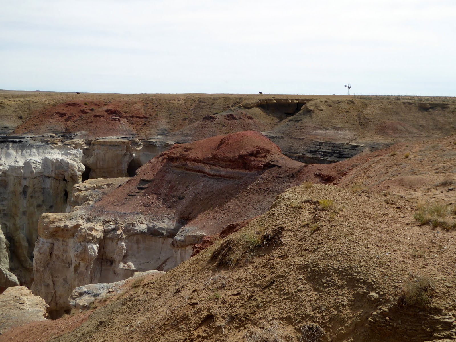
In the desert of northeast Arizona, Coal Mine Canyon is not a famous attraction. I had to ask the lady checking us in the Quality Inn RV Park for directions. She said to drive to milepost 236-237 and turn on the road to the left. There was no signage other than a welcome sign 3 miles before the turn off on the right side of the road. We would have never found this place if she hadn't given us directions. When we turned off the highway, it was a little uncomfortable driving down a dirt path that looked like someone's driveway, we were on Navajo land. Without a signpost the canyon has become quite well known because of the amazingly colorful formations that line the upper end of the ravine. We had planned to visit Bisti Wilderness in New Mexico but the weather was not cooperating. This was our next choice.
The canyon is one of many remote, little-visited sites in the Southwest where the main interest comes from the detail of the rock - the colors, forms and textures of the eroded sandstone - rather than the large scale appeal of such grand places as Zion and Monument Valley hidden away in the high desert plains of this part of Arizona - Coal Mine Canyon sits at the edge of the 120 mile wide Painted Desert.
As we were leaving after walking about, another couple of people pulled up. I guess the word is out.
Navajo Code Talkers
We knew about the Code Talkers from WWII and wanted to visit the museum and learn a little more.
During WWII in 1942 communications had become a problem. Japanese cryptographers were adept at breaking top secret military codes. Many of the Japanese code breakers had been educated in the United States where they had learned to speak English. American battle plans became known to the enemy almost immediately. The result was a huge loss of American lives. Philip Johnston, civil engineer, had lived on the Navajo Indian Reservation from the age of four, where his parents were Protestant missionaries, and had grown up speaking the Navajo tongue with his playmates. The concept of a secret military code based on the Navajo language flashed across his mind.
Marine recruiting personnel appeared on the Navajo Reservation to enlist thirty volunteers. Being fluent in both the Navajo tongue and English, each enlistee had to be physically fit in to serve as a messenger in combat. The Navajos were told only that they would be "specialists’ and would serve both in the United States and overseas.
For almost all of the Navajos, travel was a brand new experience. Some had never been off the reservation, and many had never ridden on a bus or train. The majority of them had never seen an ocean and did not realize that they would soon be a part of the ferocious war being fought in the middle of the Pacific. Several of the recruits’ families insisted that before leaving, their sons participate in a religious ceremony to pray for the young men’s safe return.
The Navajos devised a new Marine Corps military code which would completely baffle their Japanese enemies. The men devised a two-part code. The first part, a 26-letter phonetic alphabet, used Navajo names for 18 animals or birds, plus the words ice for I, nut for N, quiver for Q, Ute for U, victor for V, cross for X, yucca for Y, and zinc for Z. The second part consisted of a 211-word English vocabulary and the Navajo equivalents.
Walnut Canyon National Monument
We had driven by Walnut Canyon several times as we drove by on the way to Flagstaff but had never taken the time to make the stop. There were always so many other places to see. This time we made the stop. It was not anything we could have expected.
The 1 mile Island Trail, a loop path that descends 240 steps, then circles the island. The trail passes alongside the remains of about 20 separate Hopi ancestor dwellings, a few of which are quite intact, including a front wall with rectangular doorway from 1400 AD. The Rim Trail also has good views of the cliffs opposite, which have other ruins clearly visible.
It was a rainy day and we did not have to deal with crowds.
The dwellings were built on the underside of the rocks where the soft limestone has eroded.
The rocks are still stained with the smoke from the fires. The hole above the door was used as a chimney for that smoke.
Below is the trail around the island that we walked. Both the Rim Trail and Island Trail did not take a good deal of time to walk but well worth it.
What a deal. We already have our pass but something to keep in mind.