Tuesday, May 26, 2020

Green Mountain Falls

Going Up

There are different types of people that travel. Nomads wander, tourists want to be entertained and explorers are following the paths of people before them. 

We may not be able to sightsee, but we hiked some of the new trails in the canyon.

Green Mountain Falls is a small funky town just off Hwy 24 before Woodland Park. We would stop at the Mucky Duck for dinner or the Pantry for breakfast when they were open for sit down. For now we just enjoyed the out doors.

We took an early morning walk so scope out the steep hike we had planned for the next day. Walking along the creek and through the neighborhoods felt like a fairy tale place. Many of  the summer cabins t have been handed down through the families over the years from Texas and Kansas.

The American Discovery Trail

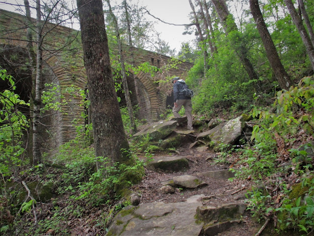
The Ute Pass Trail in Green Mountain Falls is part of the American Discovery Trail which is a national
trail — part city, part small town, part forest, part mountains, part desert — all in one trail. Its 6,800+ miles stretch from Cape Henlopen State Park, Delaware, to Pt. Reyes National Seashore, California. 
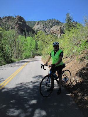
The population in Colorado Springs population has exploded, making driving in the traffic and construction more than we wanted to deal with. We passed up a couple of hikes out of Gold Camp Road.

Castle Rock Trail

It is also home to many lesser-known hiking trails, including the H.B. Wallace Reserve. Nearly all of the trails in this area climb up the steep canyon walls that line Ute Pass with a lot of elevation gain to great views in just a few miles. I was moving slow just getting to the trailhead.

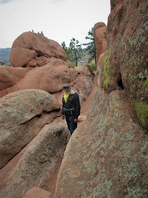
The dirt parking area is located at Ute Pass Ave and Mountain Road. Walk up Mountain Rd a few hundred yards until you see the sign for the Reserve on the right Just beyond the gate, there is a trail map and information. You can hike straight up the orange-signed steep Castle Rock trail to get to the top quickly, or you can branch off to either side on Elk Root or Peyote Pass trails. 

We passed up Elkroot for the Fat Man's Squeeze trail.  These trails ascend more gradually and add some mileage to the ascent. 
 I had hiked it five years ago with a hiking group out of Colorado Springs and wanted to show Mike what he had missed. We avoided the crowds, we actually didn't see one person on the trails of the H.B. Wallace Reserve.
 We wouldn't have returned to this part of Colorado for long if it hadn't been for the crazy situation. We had explored much the area while living there but were glad to be here for a while until Chaffee County opened from the lockdown.
 

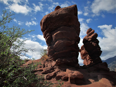
The upper portion of the trail gets even steeper with  many tight switchbacks as we made our way up past the towering Castle Rock. The trail ends at the top of the rock with a great vantage point of Ute Pass.

Top of the hill. We made it!
Our destination

The Thomas Trail


.From downtown Green Mountain Falls, we walked west up Hondo Avenue to Catamount Creek Falls at the end of the road. The few people we did meet up with stepped aside or across the road as we passed.

From the gate at the top of the street, it is an easy walk to the falls on a gravel road. Much of the trail above is strewn with rocks, and there are areas of crumbly granite near fairly steep drop offs. At the side of the falls you will see signs for the Catamount Trail. After a short but steep climb
up rocks and tree roots alongside the falls, we came to a junction with yellow painted dots marking the Felton Thomas Trail and blue dots for the Catamount Trail. We followed the yellow metal dots posted about 8-10 feet up on trail-side trees.
The Felton Thomas trail winds up and down, over rocks and under branches, and ends at a waterfall that is at its peak in late spring.  
We walked up to the first falls on days we didn't want to climb through the rocks or drive to find other trails. We would get lost in our thoughts while listening to the wind in the trees and the sound of the falls. After the rain, the sunshine would make the trees smell so good as the breeze blew through them. 

Second falls


Crossing the creek below another set of falls.


We feel lucky to have had invitations from friends to get together even at a distance or on a hike. But for now we are keeping our distance. Recently, pre covid, we had spent an evening with friends. The next day, he started feeling not so well. Several days later, we got very sick. I guess we caught him during the incubation period. That was enough to make us be more cautious during this outbreak. Hopefully soon, we will be able to take them up  on their invitations.

Being nomads during this time can be precarious. If we should get the virus, we aren't sure how we would deal with our situation. Packing up and moving is a physical exercise, especially if you are sick and having trouble breathing. We would not be welcomed in our next campground if we were ill.  We are only in a site for a limited time before we have to move for the next people. If we both ended up in the hospital emergently, I don't know how we would deal with our trailer and truck. 

With all of that, we are still glad for our nomadic lifestyle. 
We got an email that the RV parks would open earlier than expected to people staying at least 30 days. We changed our plans and made the move. Now, we are set for the next three months, which is a long time for us. We were supposed to be volunteering in South Carolina and Virginia this summer so we could spend more time with Mike's family. I am glad we got to see them before the distancing began. Unfortunately, Mike's daughter, Amanda has had her cancer progress to stage 4. Our hearts are broken. She is cherishing everyday with her children and husband.
Snow on Pikes Peak as we were leaving Woodland Park. 
The Collegiate Peaks from Wilkerson Pass.

We will be exploring and being a tourist over the next few months.  But I don't see a 14er in my future.


Tuesday, May 19, 2020

What are we doing?

We are better than this


When the virus was first spreading, a shutdown was placed to keep hospitals from being overwhelmed. Moab had requested that the national parks nearby be closed so their little hospital wouldn't be overwhelmed. Elective procedures were canceled and people learned what they needed to do to be safe and healthy.  It worked and the majority of hospitals weren't overwhelmed.
Siamese Twins in the Garden of the Gods

Then we got distracted. People pointing fingers at political parties and the name calling started. Other countries were being blamed for our situation. We lost site of our common goal. To stay healthy and beat this situation. We are people with different opinions but we are not the enemy no matter our political beliefs. 

We are all just a bunch of people trying to get by the best we can. I didn't need a governement check and don't want to  leave more debt to our grandchildren. If we all pull up our boot straps, we could actually come out of this in better place. Or we can continue to beat each other up for no other reason than to feel better than "those people".
Seven Falls in Cheyenne Canyon is closed

I am so glad we are getting outside to escape the "crazy". The people outdoors have been respectful on the trails. I see some good things happening.

Oh! And have a good day!

Thursday, May 14, 2020

Back in Colorado

Red Rocks

We are in our old stomping grounds and revisiting some of our favorite outdoor places while in Ute Pass Canyon between Colorado Springs and Woodland Park. Not being above 2000 feet elevation in the past year, we started out with easy hikes to get used to the altitude of 7700 feet in Green Mountain Falls and it was just cold, 40 F on our starts. On our second night, our pipes started to freeze.
Arizona and Utah aren't the only states that boast rust-colored rocks. Colorado has them, too. Not far from downtown Colorado Springs near Manitou Springs is Red Rock Canyon. In the 1800s, the desert landscape was used to refine the ore that came from the gold mines in nearby Cripple Creek. During the 20th century, Red Rock Canyon was owned by the Bock family, who had plans to transform the land into a vacation haven, complete with a resort hotel and a golf course. In 2003, the city of Colorado Springs purchased the land and used its red cliffs to add miles of new hiking and biking trails.

I have written about this area in the past but the beauty never ceases to amaze me.

We walk by the Red Rocks stone quarry from the late 1800's as we climb into the park for a 4 mile hike.

We had arrived on Friday of Mother's Day weekend and the campground filled up with families by evening. Kids crowded the playground running and laughing. There were many families in tents using the public bathhouse. I mentioned to Mike that this place would be shut down if an outbreak was traced to it. We would hang out in our area and watch from afar hoping the kids all stay healthy.

Once the weekend crowd cleared out, I went to the campground office to make a change in our reservation. The owners seemed stressed even though the campground only had 4 RVs scattered. When I returned home and turned on the TV, the local news was reporting from outside the campground.

 The state parks were starting to open camping but the county was not approving this seasonal campground's opening. They were allowing private campgrounds in the city with permanent residents to be open for travelers. Lone Duck was finally allowed to remain open after arguing with officials that a few of us here had no place to go with the very few open camping available. Two of the RVs have state park volunteers that had to leave their posts and needed a place to live until allowed to return.  Fortunately, during all of the controversy the campground was pretty empty. So many people trying to keep their businesses going. They did close the playground.
We have backup plans and would be fine but are glad we get to stay after driving across the country.

The few hikers we did pass kept a good distance and most wore masks. Everyone seemed courteous and glad to be outdoors stepping aside for each other to pass.

Garden of the Gods 

Both Red Rocks and Garden of the Gods are below 7000 feet elevation, making it a good place to get used to the high dry climate.
I loved coming to this park as a young girl when we would visit my great grandmother and great aunt that lived in Old Colorado City
Garden of the Gods Park is a National Natural Landmark and city park with dramatic views, 300' towering sandstone rock formations against a backdrop of snow-capped Pikes Peak and brilliant blue skies. I never get tired of walking the trails surrounding and though the park. 


The Kissing Camels
Pikes Peak

Lovell Gulch

We moved to a higher elevation of 8600 feet for our next hike in Woodland Park, our former home. Lovell Gulch is a pleasant hike through the Pike National Forest in the northwest part of Woodland Park. After hiking for about 0.8 miles we reached the Loop sign. The easier way to hike the trail is in counterclockwise direction so turn right here through a nice meadow alongside a small creek reaching the top of the ridge after about 1.5 miles.  There are some great views of Pikes Peak to the south at times.

The fuzzy pasque flowers are always a sweet sign of spring in the mountains.


It would have been fun to see family and friends while here. We would feel horrible if we were to get or give the virus to anyone. So we will just keep our distance for now. 
I am still trying to get used to Blogger's changed format. I have all kinds of fonts on this post and am not about to start over. Call me lazy. I am ok with that since this is just for fun and memories.

 More of our hikes to come as we get used to the thin air. We have until June 1 to revisit so many beautiful places and not feel like we are cooped up .


Friday, May 8, 2020

Topsy Turvy Times


My vertigo was getting worse and I finally had to give in and go to the urgent care. the physician walked in without a mask which made my heart rate increase.
I will use a telemed doctor if I need to see doctor in the future to avoid thinking about the mask situation. The doctor felt the high pollen count was affecting my inner ear causing the spinning and isn't going to improve for several weeks. He recommended that we leave Greenville because once I finish the medication the vertigo would probably return. I am not crazy about staggering around and hate that whirling feeling and there are also more tornados in the forecast for this area. There seems to be a spinning theme here.

We took the doctor's advice, pulled up the jacks and headed west. It felt good to be on the move. The rest stops were closed in North Carolina. To take a break, we
found an empty strip mall parking lot. I am not sure what truckers do for a break. Tennessee's rest stops were quite nice and open. We made it to Crossville, Tennessee with enough
time to set up before the rain hit. Driving through the middle of the country in the springtime is not for the faint of heart, especially driving into the winds
coming out of the west.

During this pandemic, having our home on wheels is working out pretty well. We can move about the country while staying "home". Campgrounds have done a good job
of remaining socially distant but open. Our reservations are in the overnight box with instructions when we arrive.

We stopped in Crossville, Tennessee because it met our 250 mile criteria. After driving in the wind the previous day, we needed a break and took a 4 mile walk in the nearby Cumberland Mountain State Park.

This bridge was another CCC project.
Cumberland Mountain State Park began as part of the greater Cumberland Homesteads Project, a New Deal-era initiative by the Resettlement Administration that helped relocate
poverty-stricken families on the Cumberland Plateau to small farms centered on what is now the Cumberland Homestead community.
During the Civil War, Tennessee's families and neighbors were divided between joining the Union or Confederacy leaving many split forever. The eastern part state
remained with the Union and western towards the Confederacy. The war also destroyed so much farmland and families. People seem to be as divided today in our political
environment.
The bridge was built over Byrd Creek as an Eagle Scout project.

The rhododendrons were starting to bloom.
t
We were the only people on the Byrd Creek Trail, maybe because we get up so darn early and it was cold.


We had visited the southern section of the Natchez Trace a couple of years ago and heard the northern section was even prettier.
The campground was right across the road from an entrance making a bike ride easy for us.
 My vertigo was getting much better.


We could picture the Chickasaw, trappers, outlaws and travelers feet creating the 440 mile Old Trace path.
Fall Hollow Campground is in a dead zone. No TV and very slow internet is making staying sane easier. I was listening to the news and people's
opinions more than necessary before leaving South Carolina.


We drove in the early mornings to dodge the afternoon storms and 70 mile per hour wind gusts to get through Missouri and Kansas as quickly as possible, avoiding Dorothy, Toto and the Wicked Witch of the West.

Our summer plans have been constantly evolving. We cancelled our Quebec plans and our volunteering positions. Now, we are back in our old stomping grounds of Colorado and will need a little time to reacclimate to the altitude. Oh yeah, snow is in the forecast! Do you think Mother Nature is trying to tell us something?


Cuenca, Ecuador

An Expat Destination The morning after returning to Quito we boarded an hour-long flight to Cuenca. Driving up the winding roads would have ...