Friday, September 8, 2017

Hiking in the Black HIlls

Lots hills to climb

On our way back to Colorado, we didn't want to drive the entire way without a stop. The Black Hills was a good stopping point with so many hiking options. It was hard to decide where to begin. Every trail we took was a climb, hence the name Black Hills. We were staying a couple of miles outside of Custer, we started with a nearby trail.

Big Rock Park

In the town of Custer is Big Rock Park with Custer Skywalk. Trail with 55 steps to an overlook of the mountains and spires. Once we got to the top, we could only make out a shadow of the mountains because of the smoke. But it was still a good walk.


Once we reached the top, there were more stairs to climb. The smoke was still heavy from the Montana fires. 

The Willow Trail

The next day we drove north to hike the Black Elk National Forest and do some geocaching since there were 11 on this trail.

Mike had to climb for this geocache. My legs were a little (a lot) too short.


Sylvan Lake

It was a beautiful morning as we headed by Sylvan Lake to the Sunday Gulch Trail. It was Sunday after all. This trails had many boulders to climb over.

Sunday Gulch Trail


This trail was for walking under a boulder.


This narrow tunnel was for driving through one vehicle at a time. Our mirrors almost touched the edges.

The Cathedral Spires


Raspberries all along the trail were tasty.
 
We could hear the climber calling to each other while climbing the side of the giant rocks.


Heading to Harney Peak we made a wrong turn but managed to get back on track. Sometimes GPS and a map don't work.

The Black Hills are a real treasure. We could see ourselves returning since we missed many places we would like to explore.


Sunday, September 3, 2017

South Dakota's Badlands

The Badlands heating up

The thermometer hit 96 degrees our first day in the Badlands. We were able to get out and see some of the sights before it heated up too much but decided to get up and on the trail by 7 am the next morning. It was good to have the hiking boots back on.
  As we were heading out for our peaceful early morning hike, we came up on this big horn sheep. We gave him plenty of room. He didn't seem bothered by us as he dozed in the sunshine.
The air was nice and cool with a breeze in the morning.
 
Erosion began in the Badlands about 500,000 years ago when the Cheyenne River captured streams and rivers flowing from the Black Hills into the Badlands region causing erosion to start. Modern rivers cut down through the rock layers, carving fantastic shapes into what had once been a flat floodplain. The Badlands erode at the rapid rate of about one inch per year and will erode completely away in another 500,000 years, giving them a life span of just one million years. Not a long period of time from a geologic perspective.


This guy was still hanging around once we returned from our hike. We also saw small deer and prong horn antelope. Fortunately, no rattlesnakes.


The sea that covered this area drained away with the uplift of the Black Hills and Rocky Mountains, exposing the black ocean mud to air. Upper layers were weathered into a yellow soil, called Yellow Mounds. The mounds are an example of a fossil soil, or paleosol. Each of the colors and layers represent an era thousands of years in the making.


We ran across a huge herd of bighorn as we were leaving the park in the morning but were too far away for a good picture. There were plenty near the road and sometimes blocking our path.


This must be the way to the Notch.
After wandering through a canyon, this trail climbs a log ladder and follows a ledge to "the Notch" for a view of the White River Valley. We watched for drop-offs. Not recommended for anyone with a fear of heights. It could be treacherous during or after heavy rains.
Climbing down turned out to be a little more difficult. The top stairs were quite steep and long steps for short legs. As I was climbing down backwards and my knees bending up to my chest the lower I got, Mike told me to turn around and try going forward. It had leveled out enough that I just walked instead of practically bear crawling backwards.

 OK we will keep to the right since it looks like a person could easily slide on the gravel.


We tied several trails together and made a nice day of hiking. One trail had molds of  the fossils that had been found in the area and the history.  Alligator fossils indicate that a lush, subtropical forest covered the land. Most fossils found in this formation are from early mammals like the three-toed horse and the large titanothere. You can google that one if you are curious.
 
 We managed to pick up a few geocaches in the town just outside the park after our hike in the small town of Interior . They must be hardy people that live in Interior with hot summers and tough winters.


For eleven thousand years, American Indians have used this area for their hunting grounds. Archaeological records indicate that these people camped in secluded valleys where fresh water and game were available year round. Eroding out of the stream banks today are the rocks and charcoal of their campfires, as well as the arrowheads and tools they used to butcher bison, rabbits, and other game. From the top of the Badlands Wall, they could scan the area for enemies and wandering herds.
 
Toward the end of the 19th century as homesteaders to claim moved into South Dakota to claim their 160 acre homesteads. The U.S. government stripped American Indians of much of their territory and forced them to live on reservations.
We had driven by this area in the past when the temps were well over 105 degrees. This time, we were glad that we took the time to stop and visit the area and learn a little more.
The skies have been smoky due to the fires in Montana but makes a nice sunset as we head to the Black Hills.
 

Friday, September 1, 2017

Nurses needed in Texas

I have received emails from companies I have worked for in the past as a traveling nurse today requesting help in Texas. They are needing nurses who will work 64 hours a week and willing to live in the hospitals or motels for one month. I wish I could but don't think I could work that many hours a week even for $4800 per week. Things have to be tough right now and regular staff are just trying to deal with their own lives.
 
In the past, I worked in California during the fires so regular staff could deal with their tragedies and was glad to be there as ash was falling on our car and air deemed too dirty to breath.  
 
Any nurses or other medical staff out there up for the challenge, let me know and I will get you in touch with the right people. This will be a long and trying time for our friends in Texas and LA.

Wednesday, August 30, 2017

Driving across the Midwest

Driving across the Middle

Mississippi River's back waters

We headed to Goose Island in the backwater of the Mississippi River. Yes, they have large mosquitos but  turned out to be a nice and interesting area near La Crosse, WI for a short time.
La Crosse has been on our radar since reading about their trails and bike riding. Besides, we were driving right through the area.

 Goose Island turned out to be a very large and lovely campground with large spaces. We enjoyed our walks along the river and learned about people taking their boats out to sandbars to camp. One fellow has a camper shell on his pontoon for protection from the elements and bugs while camping on the Mississippi sandbars.
 
Lock & Dam #7 is one of the most visited lock and dam structures on the Mississippi River and lies in the rolling Upper Mississippi River Valley near La Crescent,  MN and La Crosse, WI.

 
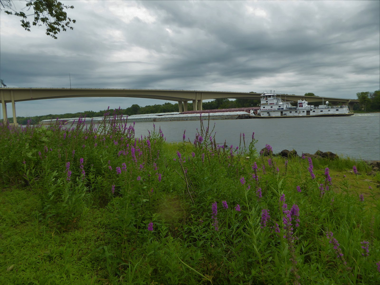
 This lock is located at one of the most scenic spots on the Great River Road. The river is miles wide at this point, with many islands. The locks and the main dam control structure are located on the Minnesota side of the river.


All types of vessels use the lock during the navigation season, which extends from mid-March through mid-December. The lock provides a vertical lift of 8 feet for boats, ranging from canoes to large towboats with barges. The Upper Mississippi River serves as a main artery for Midwest grain bound for both domestic and international markets. More than 15 millions tons of cargo pass through the lock each year with farm products, chemicals and coal the major commodities. Also, more than 13,000 recreational craft use the lock annually.

Pool 7 which is the lake created upstream from the dam, forms a valuable upstream environmental habitat and resource for migrating waterfowl. Sand bars along the channel offer opportunities for recreation.


We watched as the tugboat maneuvered the barges that were tied together into the lock very slowly with only inches to spare on each side. Half of the barges were released and the tugboat pulled the last half back out since there was not enough room for all of them. The first half was lifted and then the second half sent though and then the two halves rejoined. It was quite a slow process.


This 24-mile trail travels through prairies and backwaters of the upper Mississippi River valley. Built on an abandoned Chicago-Northwestern railroad line, the trail has a finely crushed limestone surface suitable for walking and bicycling for much of the year and snowmobiling, cross-country skiing and snowshoeing in winter. The Great River trail is within a larger area called the Mississippi Flyway and passes through two National Wildlife Refuges.
 There are several Rails to Trails that run along the rivers and marshes around La Crosse. The first day was a quiet, long and mostly straight trail. We paid our $5 for the trail pass before our ride.
 

La Crosse's Friendship Gardens


 We enjoyed the beauty of the Riverside International Friendship Gardens. This collection of public gardens celebrates La Crosse’s sister-city relationships with communities in China, Germany, France, Russia, Norway and Ireland.


Flying Goose

There is a lot of open space with corn, soybeans and sunflowers as we drove through the Midwest. We stopped at Flying Goose Campground but decided to forego seeing the Spam Museum.
 Our morning walk as the sun was coming up.
Our next stop was in Mitchell, SD and the Corn Palace.

 The Palace is redecorated each year with naturally colored corn and other grains and native grasses to make it “the agricultural show-place of the world”. They use 13 different colors or shades of corn to decorate the Corn Palace: red, brown, black, blue, white, orange, calico, yellow and now green corn! A different theme is chosen each year, and murals are designed to reflect that theme. Ear by ear the corn is nailed to the Corn Palace to create a scene. The decorating process usually starts in late May with the removal of the rye and dock. The corn murals are stripped at the end of August and the new ones are completed by the first of October. Looks like we made it in the nick of time.


 The 50-foot-tall statue depicting a young Native American woman with a star quilt is made entirely of stainless steel and weighs about 50 tons was built along the banks of the Missouri River.
We made across those states and pulled out our hiking boots in Western South Dakota.


Cuenca, Ecuador

An Expat Destination The morning after returning to Quito we boarded an hour-long flight to Cuenca. Driving up the winding roads would have ...