Showing posts with label hike. Show all posts

Monday, August 17, 2020

Hartenstein Lake

A Fun Summer

As you can see, we love our public lands and feel privileged to spend time out here. Unfortunately, much of it is being sold off for as little as $1.50 per acre for oil and natural gas exploration. Not only have we lost public land but the decency in how we as owners and the land are being treated.

Colorado is dealing once again with wildfires, 4 of them and warm temps. We have smoke blowing in over the mountains but fortunately for us, most is going north. On our final day at Lake Dillon, the smoke starting getting much heavier so we headed back to Buena Vista for our last two weeks. The mornings are a cool 50F in the mornings and it cools off quickly once the sun goes down.

Hartenstein Lake Hike

We were up early to beat the predicted thunderstorms and the crowds. Who's idea was that?

 12 miles up Cottonwood Pass heading west from the stoplight at Main Street in Buena Vista is the Denny Creek Trailhead on the right. There were several cars at the parking lot when we arrived. It looked like several people had been car camping before ascending to Mt Yale (14,000+ feet) which shares the same trailhead, for an early start.
A steamy mist was rising from the trees as the sun started warming them.

Climbing straight uphill as soon as we hit the trail was a great way to acclimate to what lies ahead. We hiked through pines and aspens up switchbacks until reaching a more gentle path.


Coming upon the turn off for Mt. Yale (14er) at 1.3 miles, we hiked past and on to the forest, over several creek crossings until emerging out of the trees and into incredible views.


Turning here we had only a mile more to reach Hartenstein Lake. This last mile was packed full of views all around and sprinkled of wildflowers.

'We heard the chirps of several families of marmots.
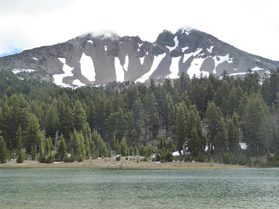
A bit marshy in spots but so blue and so quiet, it’s beautiful. The lake sits at 11,480 ft. in elevation
The terrain on the way to Hartenstein Lake told stories of harsh winters with fallen trees and a windswept landscape.

Happy birthday Mike!
The Trailhead Co. is a favorite stop in town after a hike or bike ride for an iced tea before our last couple of miles.
A favorite food truck for us with picnic tables under the trees.

Cycling in Summit County

We were fortunate to have another visit to Summit County.
The Ten Mile Canyon Trail is one of the best maintained bike trials we have ridden in from Frisco to Copper Mountain. The views aren't bad either making the climb more pleasant.


Someone threw a block party in Frisco and no one came. Wait, we were there.

The next day, Mike invited me to take a short ride towards Breckenridge. This ended up being a 26.5 mile ride. I am not sure how he determined this was a short ride after riding 25 miles the previous day. 

Our time spent in the Arkansas River Valley has given us the opportunity to visit many places and hikes we had not seen even though we lived 90 miles away. There are still very few cases of COVID in Chaffee County and everyone (almost) wear masks and keep distant.

One More Hike

We had planned to take a short hike on the Lily Pond Trail but had a change of mind once we arrived at the South Mt Elbert Trailhead overlooking Twin Lakes and Mt Elbert (the second highest 14er in the lower 48 states below Mt Whitney).

Twin Lakes

Being forced to slow down this summer has given us a chance to listen and wonder while in this strange world. We are humbled and appreciate our mobile life even more now. We just changed up the plans and enjoy each day. Travel and birthdays change how we think.

There is so much noise distracting us from seeing what is happening. We hope that no more of our public lands will be lost to developers before our grandchildren get to experience these wonderful places.


Wednesday, May 29, 2019

Tualatin Valley and Saddle Mountain

A quick month at LL Stubb Stewart

Our nomadic life is constantly changing along with our address. As a traveling nurse, we would choose three month travel contracts based on the areas we wanted to spend time. My first was contract in Connecticut. We would take the train to NYC or drive to Cape Cod on my 4 days
off, returning in time for my 3 days at the hospital which can get pretty tiring. But what an opportunity to see the country. As we reached San Francisco, we slowed down, learning to explore closer to home and enjoy the immediate area, finding ourselves dancing to the music in the park near our apartment or riding our bikes along the bay.

 The past 4 years, we would travel 6 months, returning to Arizona for 6 months to work and refuel after the excitement of new places and constant moving. After several years of returning to the same place, it was time to mix it up once again. This time the opportunity of staying a month in these wonderful state parks and feeling like we are contributing is a real treat. Also, not having to find a place to stay over holiday weekends is a bonus.

Relief Camp Host is something we would do again in the future.  

Tualatin Valley Trails

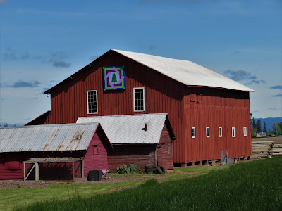
Along the Wine and Quilt Trail, 60 quilt panels have been installed at local area farms and agriculture related businesses. Each quilt tells the story of the property owners and their relation to quilting. 


One draw for us was the 51 mile Tualatin Valley Scenic Bikeway that includes the 21 mile Banks-Vernonia Bikeway, which passes through quiet rolling hills and 
 farm country roads with little traffic. Many people from Portland ride the 30 miles along the bikeway to camp at Stubb Stewart's hike/bike camp, one of our favorite places in the park.

Mt St Helen in the background

Mt Hood in the back

The county has put a lot of effort and money into its smooth roads for cyclists. 

Trail from Banks 


Saddle Mountain Recreation Area


Saddle Mountain Trail, halfway between Fort Stevens State Park and LL Stubb Stewart, had been on our radar for a while. Our window to hike it was closing as our time to leave and head back to the ocean was fast arriving. 

Even though it was raining on our last days off, we put on our rain gear and headed up the trail.


If the trail’s natural beauty and wildflowers weren’t enough to entice us to the top, the panoramic view from the summit did.  We hear on a clear day you can see the sweep of the Columbia River as it enters the sea, miles of Pacific shoreline and on the eastern horizon, the Cascade Mountains in Oregon and Washington. We plan to return on a clear day to check it out.


I was thankful for the hiking poles on the slick wire holding the trail together.
The trail is steep and difficult in spots, with a 1,640 foot rise in elevation over 2.5 miles.
The first and last half miles were the steepest. We felt each step in our thighs on the way up. On the way down our knees were thankful for the poles to hold us from sliding.

We  hear there is a view.


We didn't get to see the views on our hike or enjoy the harvest from the farms we rode our bikes by this month. We plan to return in August to be interpretive hosts at Stubb Stewart so we can remedy that. But that is a whole other story.

 The berry Mike brought to me as a gift wasn't quite ripe. It wasn't so much a gift but more of a chance to find out how ripe it was without testing it himself.  Needless to say, this did not get him any cudos.
Salmon Berries
 I occasionally wonder why we can't be content living in the same place with occasional trips. But realize that we could and are appreciative of the opportunity we have to travel, meet new people and
see new place as we attempt to find balance in our lives while we still can.

Wednesday, July 20, 2016

Three Sisters Wilderness

We decided to get up early to hike in the Three Sisters Wilderness. Driving up towards Mt Bachelor, the clouds became thicker and temps lower. Once we arrived at the trailhead, the temp was 49 degrees. With several trails to chose, we chose the one that followed the creek to the Green Lakes and turned out to be great. There were many waterfalls around every corner with views of the volcano flow from the South Sister as we got higher.  The pictures we took don't do the area justice.
In the evening we found a group playing some pretty good Bluegrass that were quite entertaining.


This bridge was just 1/4 mile from our truck and when we returned the steps were much higher up than when we first started our 9 mile hike.


There are some huge bullfrogs around here that get loud at times.


The past two weeks have flown by with so much to see and do, requiring a nap in the afternoons and occasional days off to read a book.


South Sister


Middle and North Sisters overlooking the first Green Lake. There were more ahead.
.
 

The marker said 4 miles each way but GPS read 9 when we returned. Taking side trips off the trail and then going further once we arrived just to see what was around each corner added that extra mile.

 
The GPS had not been updated in far too long, so we took the morning and used the park's internet to download the latest version instead of using our data. That took quite a while. I think we get lazy about keeping things up sometimes thinking we are on vacation instead of living our lives this way.  Starting out in a whirlwind, we had to learn to settle down pacing ourselves and don't need to see and do everything. We're just figuring what we need to do to make it right for us. 
 
On to Idaho! (After a nap)
 

Cuenca, Ecuador

An Expat Destination The morning after returning to Quito we boarded an hour-long flight to Cuenca. Driving up the winding roads would have ...