Tuesday, April 17, 2018

More Utah

Spring has been stirring up some wind and storms this April. We switched directions from Capitol Reef since we would have no hookups, the temps were going to be in the 20s with limited sun for our solar panel. Also, we would have to drive a couple of miles on the Grand Staircase's winding road with very steep drop-offs on each side. The thought of towing our trailer over it without wind left me leery. Driving over it with wind gusts in the 40-50s wasn't going to happen as far as I was concerned. Fortunately, Mike felt the same way. We headed west to Panguitch, think sandwich with a "P", just outside of Bryce National Park.
Once in Panguitch, we drove to Bryce Canyon just to enjoy views from the truck due to snow and high winds with  gusts at the highest point of 77.8 mph.
 
 It had been 9 years since our last visit and hike and didn't disappoint.
 

Natural Arch

 We wanted to be able to get out and do a little hiking in the area. We saw a geocache was a short hike on the Cassidy Trail once we returned to Red Canyon. The views were nice with much less wind.
While geocaching in town the next day, we kept running into a son and dad out doing the same at several locations.
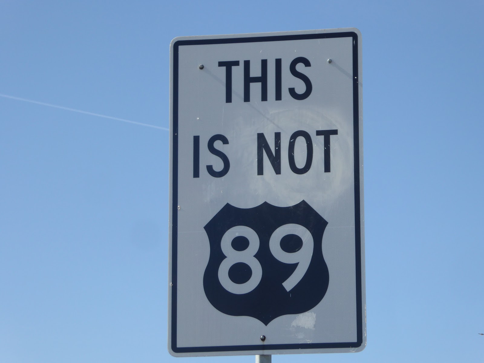
I have never seen a sign tell you what is not the name of the highway.
 

Provo, Utah

 
Another change in plans were made as the weather forecast was calling for heavy winds on the day we had planned to drive north from Panguitch. There is no reason to drive in blustery winds. We headed out a day early for an easy 200 mile drive to a campground near Utah Lake.
 
The Provo River Trail runs from Utah Lake across town into Provo Canyon. The croaking frogs and birds enjoying the sunshine were a big change in the sounds we were used to hearing in the desert.  We were ready for the cool spring air.
 
Our rides usually involve a snack. We found a crepery along the trail that brewed a mean coffee to go along with the great crepe.
 
After our snack, the clouds were starting to roll in. Fortunately, we made it back to Utah Lake just before the heavy winds hit.

What a beautiful morning or so it seemed.  The snow storm seemed to be clearing until we entered Provo Canyon. The snowfall became heavier with blowing winds blocking the view of the waterfalls and almost everything else causing us to turn around before reaching Sundance.
We mad a stop in Spanish Fork at the Krishna's Lotus Temple that was recommended on Roadside America. Religions have always been interesting to me. In college, I took a course on religions so maybe I could understand a little better.


We had to take off our shoes before walking up into the temple.


After touring the temple and visiting the animals, we had a tasty Indian vegetarian lunch and visited with a lady that lived and worked at the temple. We didn't make it down to see the sacred cows. I thinks she was disappointed that we missed them.
 
 
The llamas are rented out as pack animals in Utah, Wyoming and Colorado by the Temple  as a source of income.
 
Heading northwest and hoping for sunny days.


Saturday, April 14, 2018

Escalante, Utah

Taking a drive on the Scenic Highway 12 through the Red Canyon to Escalante for our week stay. 

Scenic Highway 12

We had to make several stops outside of Bryce National Park along the highway to oooh and aahhhhh. 
 
Driving can be a bit unnerving along the Hogbacks near Hell's Backbone. Mike insisted on driving the winding sections that have severe drop-offs on both sides without guardrails. He has control issues or doesn't trust my driving.....

Lower Calf Creek Falls

 Our 6 mile round trip hike to the lower falls in the Grand Staircase after hiking 2 miles on another trail was like being in a candy shop with so many trails to choose.
  This hike was just rolled along Calf Creek in the sunshine but not too hot. Much of the trail is through sand in a dry creek bed with markers identifying petroglyphs on the distant walls.
We passed by mineral-streaked cliffs of Navajo Sandstone and beaver dams with fish in the creek on our way to the pool and falls.
 
The cool breeze over the top of the 130 foot falls gave us a refreshing break from the sunshine as we sat under the trees for our snack next to the water fall. We were tempted to wade in the pool but just enjoyed the fresh air. I hate putting on hiking boots half way through a hike. They never feel quite right.
We had a nice surprise and stopped for a treat and lemonade at Kiva Koffee in the middle of the National Monument while driving back from our hike.
 
While enjoying our refreshments, a man joined us after overhearing us discuss our hike. Once he left, a local stopped to give us some tips about hikes we were planning to take. Then another group of locals added their thoughts. Everyone was very welcoming.
 We drove the Burr Trail outside of Boulder to hike the Deer Creek Trail that wanders along Deer Creek pastureland.

Stopping for a picnic before calling it a day, we returned to visit the Hole in the Rock Museum. Those were some hardy and maybe a little crazy,  Mormons. They had to be hardy to survive. The pictograms and story plates were interesting and awe inspiring. Click here if you would like to read the story.
 
Driving through small towns, often they don't seem to have much to offer. During a morning walk from the campground, we took sometime to find some great places like this organic grocery store and coffee shop, or in my case tea.


I like this fellow's classy pack.
 Part of the way though our visit, I was feeling under the weather. Realizing that if we needed an emergency room, we weren't sure where to go. We knew there was a clinic on the edge of town with an after hours number. But with no phone service even with roaming and the internet down, we would be out of luck if we needed 911 or even the clinic. A snow storm with high winds on the way with temps in the low 20s, we made a change in plans and headed west.


Wednesday, April 11, 2018

Kodachrome Basin


.

We set out for our 40 mile drive from Escalante to Kodachrome Basin with a plan to stop at Subway to pick up lunch. It was Sunday, the town is very small and many places close on Sundays. I asked the lady attending the gas station where the Subway was located, if Cannonville would have a place to get lunch. That would be a no, it is Sunday and it is a Mennonite town. She did suggest Boots, a restaurant 5 blocks down Main street and take a right. The workers in Boots seemed to be just waiting for us as we bellied up to the bar and whipped up a giant sandwich for us to share on the trails. We will remember to stock up at the grocery store on Monday 

Staying in southern Utah and seeing lots of red dirt was our plan because Arizona was getting pretty hot which brings out the pollen and rattlesnakes. North of this area was still getting hit with winter storms.


We didn't see anyone on the trails until we returned to the truck. This state park doesn't get a lot of visitors due to its proximity to the national parks nearby. 
 
 
I see a gnome. Of course, you start seeing all sorts of things after wandering around the desert for long enough.


This is the oldest and most healthy cryptobiotic crust I have ever seen. The crust is a community of organisms that live on desert soils. It provides critical nutrients to plants, absorbs and holds water and aids in preventing erosion. The lumpy black crust is in its mature state, but is nearly invisible in early stages and easily destroyed by walking on it.
 
I feel sad and frustrated when I see people ignoring the signs to stay on the trails, traipsing off across the desert destroying the crusts.  But then again, people don't know what they don't know.


Couldn't miss the Secret Passage.


Mike saw a duck here.
 
After taking the 6 mile Panorama Trail, we hit the shorter 1 1/2 mile Angel Palace Trail.
 

We saw a KOA as we were leaving Cannonville and thought we could buy a candy bar there since everything else was closed and a Payday sounded great. Surely, someone would be manning the store. Wrong again.
 
Time to head back to Escalante or as I call it, the land of much wind.


Thursday, April 5, 2018

Hiking in the slot canyons

Hiking the Staircase

Toadstools in Escalante Staircase

On our previous visit to Lake Powell, we had taken a couple of organized tours, missing most of the Grand Staircase outback. This time we did more research to find hiking areas both on the Navajo Reservation and BLM and where to get the required permits.
On our way to the Toadstools, we also stopped at the Big Water BLM office and Dinosaur Museum for more information. There is little to no phone service out here. We wanted to be sure we were taking good roads with good directions, food and water.


Along the creek bed hiking trail, we passed variegated walls of sandstone that were quite pretty. 


Many toadstools had lost their tops from erosion.
 
  After the Toadstool hike, an easy 1.6 miles, we picked up some Subway and headed over to the Waterhole Canyon Trail on the Reservation to get in a longer hike. A $12 per person permit was required. We had to drive back to Page, go down a couple of more roads to find the office selling permits before driving back to the trailhead.

 The wind gusts were getting pretty strong, sandblasting our faces, causing us to finally call it a day and return to the Wahweep Campground to have our picnic while making better plans for our next two days of hiking.


Wire Pass and Buckskin Gulch Slot Canyons 

The BLM ranger had suggested we take the hike through Wire Pass into the gorge of Buckskin Gulch of the Vermillion Cliffs of the Paria Canyon since the water in the gulch was going to be up to our waists and very cold.

We drove Highway 89 to House Rock Valley Road, turned left  and drove 8.4 miles on this dirt road. Fortunately, it had been dry and the road had been graded, which made for an easy drive, paid our $6 a person (dogs are also $6) at the trailhead and hit the trail.
 
 For 12.5 miles Buckskin Gulch is a very narrow gorge 100 to 200 feet deep, flanked by walls of Navajo Sandstone. Buckskin Gulch is renowned not only because of its continuous challenging narrows, but also because there is no other canyon like it in the world and thought to be the longest.

 We took the Wire Pass Trail to Buckskin, which is a short 3.6 miles round trip, with its narrows even more confined than those in Buckskin. Then we headed up the gulch for another mile before turning around. 
 

We enjoyed the cool 47 degrees temps as we started out.

At the end of Wire Pass Slot is a big rock with a big drop for our short legs. We turned around when we could tell how to get down safely and found a trail that went along the top of the gorge and climbed over and back down.

Below is the exit of the slot and a scramble down. The trail got more beautiful as we hiked. I took so many pictures it was difficult to chose which to post.

The petroglyph arch at the confluence of Wire Pass and Buckskin Gulch.

As we continued through Buckskin, the water wasn't very deep.


We thought we would try to climb over the rocks on the way out.
Mike made it with me telling him where to place his feet.

I reached a place where I needed a little boost and was glad that I kept my pack on. Mike grabbed the pack and gave it a little pull so I wouldn't fall backwards.
 
Our blue truck turned red after driving on the dusty roads.

Waterholes Canyon on Navajo Tribal Land

On our third day of hiking, we drove out of Page 3 miles on Copper Mine Road to Le Chee to purchase the $12 per person permit to hike on Tribal Land. Then drove back to the small parking area on Highway 89  for our hike. We only saw 2 other people on the way in but a few more as we exited the canyon. There was also no one pushing us along to hurry us like the Antelope Canyon Tours.
We finally found the place to purchase the permit to hike.

We found the cairns leading us into the canyon.


The sandstone was nice and grippy but I still crab walked when the sand was loose.


The clouds came over making the photos better.
 At the top of the ladder was a very narrow path we had to squeeze through.
 
 After returning to the trail head, we walked to the highway 89 bridge and found the car that had wrecked off of it and another ladder. It was another short hike of 3 miles round trip and a little extra walking but a good morning walk.
 
We have some longer hikes planned once we leave Lake Powell. It is definitely good to be back on the road. We are finding that there are more people from Asia and Europe than ever visiting our treasures.

The stars shine so brightly in the very dark sky at night as we sit by our fire at night.


Cuenca, Ecuador

An Expat Destination The morning after returning to Quito we boarded an hour-long flight to Cuenca. Driving up the winding roads would have ...