Friday, July 17, 2020

Hagerman Tunnel Hike

Another Ghost Town?

 As more and more people continue to get outdoors to recreate, Colorado had a major change starting July 1, 2020 for anyone who wants to access a State Wildlife Area or State Trust Land. Any visitor 18 or older will now be required to have a valid hunting or fishing license to be on the land.

As Colorado's population continues to grow the state’s trails and wildlife areas are feeling the impacts of increased visitors.

One of the biggest issues with the other wildlife area is that people don’t stay on the trails. They like to kind of go wherever they want to go and that’s a big impact, that’s really pushing wildlife away. For visitors from out of state that can be $80-90 each person.

The Hagerman Tunnel Trail was next on our list of trails to hike. We drove to Turquoise Lake near Leadville, taking the Hagerman Pass turn off to the Windsor Lake Trailhead 3.5 miles down a dirt road. It wasn't marked very well but it lived up to our hopes of a nice hike once we figured out which trail to take.

The signs are hard to read, so I interpreted them for you below.
Born in 1883 and died in 1921 the Colorado Midland Railway was the standard gauge over and through the Colorado Rockies. It had less than 350 miles of track. Never made any other excited the imagination of railroad lovers as have other railroads in the nation- the section of railbed that you are about to
walk over leads to fallen in snow sheds over trestles no longer in existence to the lofty Hagerman tunnel, 11350 feet above sea level that pierced the Rockies.
In your walk you will see the almost forgotten site of a magnificent wooden trestle 1084 feet long.

We started up at a gradual climb in the Mt Massive Wilderness, making this an easier hike with less elevation gain (675 feet in 6 miles) than our past few. 

I wonder if we need a fishing license to hike here. 
The higher we climbed, the more impressive the views with a few water crossings that weren't too difficult.

I found some Columbine along with lots of other wildflowers.
I got a kick out of this sign. But what impressed me more was the fact that this was an actual town , way up in the mountains. It sounded like a wild place.
Typical of the short lived ghost towns for the Rockies- was Douglas City- It was built for Italian constructions workers who labored in this area and helped build the Midland Railroad,
Hagerman Tunnel and trestles. This one street "city" had eight saloons, mostly in tents and a dance hall. Here the "Professor" played the piano wile the ladies of the evening too jaded for Leadville entertained and took the laborers' money. The wild city was the scene of drinking, shooting fighting and knifing and other innocent pleasures.


There are several cabin remnants left.

This is the east portal of the Hagerman tunnel, the highest railroad tunnel in the world at the time of its completion in 1887. The great tunnel is at 11,035 feet above sea level. Its cost $200,000 and was replaced. It is hard to read the rest until DANGER DON'T ENTER.
We didn't climb back to the tunnel behind me. The snow was too slick.


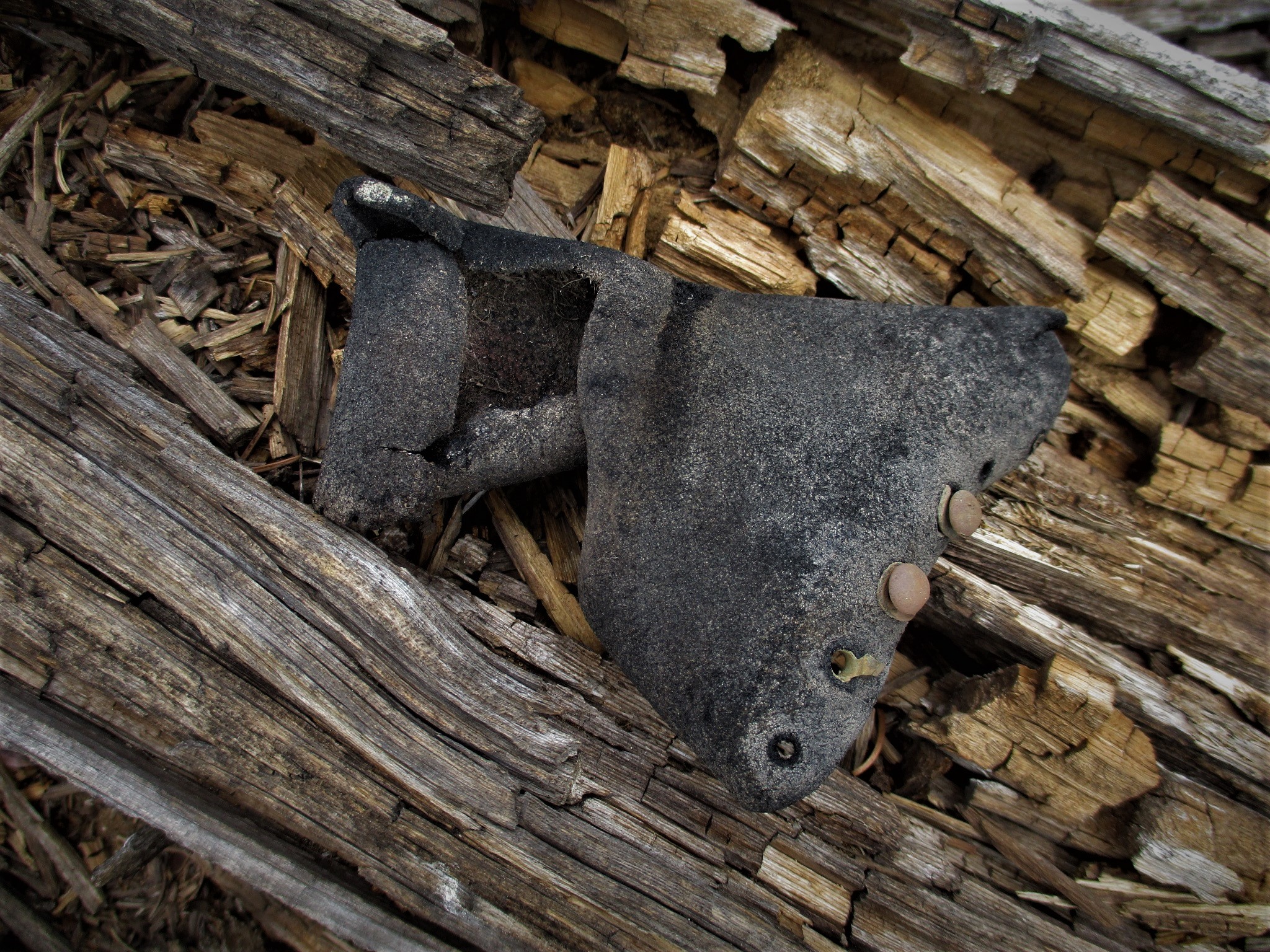
As we were exploring the remains of the town, Mike found this piece of a ladies leather boot and other items. We could imagine life then and left everything as we found it.


We found some great hikes high in these Rocky Mountains and are glad we had time to acclimate before attempting them.

Lunch with a view at the top of the hike overlooking Opal Lake.


Friday, July 10, 2020

Ghost Towns

Clear Creek Valley

Even though we are restricted in our travels, we can still explore where we are now. You would think that we had seen everything Colorado had to offer after living here for many years. But we found ourselves going to the same beautiful places that were in our comfort zones. Now we spend our days looking for places and trails we missed while living our regular daily lives.

I am taking my time posting on the blog since we aren't going anywhere soon. It is fun to go back and remember our days out. Kind of a do over. It is too easy to move on to the next adventure and not savor the one we just finished.

Driving north on highway 24 towards Twin Lakes, we passed a sign for Clear Lake and Vicksburg on county road 390. After some research we found that Clear Creek Canyon is full of ruins from Colorado’s early mining days. There are four remaining ghost towns in the canyon, which lies just west of Clear Creek Reservoir from Highway 24.

Clear Creek runs the length of the canyon to the Arkansas River. Miners began prospecting tributaries to the Arkansas River in the 1860’s. Most of the old mining towns reached their heyday around 1890. 

After turning off Highway 24, it was 9 miles of dirt road to Vicksburg and 14 to Winfield. The road was good until we entered the national forest. Then it got bumpy.
The first old town we reached on CR 390 is Beaver City, the first mining camp in Clear Creek Canyon. Two of the original twenty buildings remain.

Rockdale is also known at Crescent City mining camp.

Vicksburg and Winfield are the best preserved out of the four ghost towns.
Vicksburg was the second largest town in the canyon, with around 600-700 people during its peak. A museum is open some weekends during the summer. There’s also a recording outside that
tells the local history, available 24/7. Many of the cabins in Vicksburg are privately owned, and seasonally occupied.


 Missouri Gulch hike was steeper than we were prepared for but a nice stop.


Dexter


Winfield
Prospecting was done in the Winfield area in 1867, but the town didn’t reach it’s heyday until 1890. It had 1500 hundred residents and was the largest town in the canyon. There is a furnished school house and miner’s cabin, open on select weekends in summer.

Not a bad place for a picnic. The ghosts didn't even bother us.


That was some big avalanche!

I recently had a crown fall out while flossing. Imagine the stress I felt about going to the dentist. But first of all I had to find one that would see me. The short version was it went well. They wore N-95 masks and I felt a little uncomfortable taking off my mask around new people. A week later, I woke with a cough and stuffy nose. Benadryl took care of the allergies. When did I get so paranoid? Maybe too much TV news.

Who knew we had missed so much right in our own backyard while living in Colorado?
Not a bad way to end the day!

Sunday, July 5, 2020

Cottonwood Pass

Summer in the Rockies

When we moved to Colorado to see how the virus would play out, we didn't really have a plan. I had called a few RV parks they were either full or too expensive for our taste. Sandra from Valley RV Park called and the price was less than half of the nearby parks. The location had plenty to keep us distant and busy. We were in.

We are glad to be in the mountains with very few cases of Covid here. The locals have a more relaxed attitude than in the cities on the Front Range. (It's all good) They put on their masks and carry on without needing to exert their "rights". Chaffee County had done a hard lockdown at the start of the virus and people made a quick adjustment to watching out for each other. 

Now that the county is open, people from the cities arrive on the weekends. The locals take a step back to give each other space. Those that have arrived for their holiday seem to say damned to the distancing. They are on vacation and out of the way.

Heading west from the stoplight in the middle of Buena Vista leads to Cottonwood Pass. We get an early start and avoid the weekends to beat the crowds on the trails.

The pictures are from the first part of June and there was still plenty of snow in the mountains.
Hang on! The wind will blow you to Kansas.

Taylor Reservoir on the west side of the pass.

It was fun to visit Taylor where my parents would rent a cabin in the summer. We stopped for hot tea and coffee to go with our breakfast burrito.

One more view from the top of Cottonwood Pass.
Another day, we cycled up towards Cottonwood Pass as far as the shoulder was wide enough for us to feel safe. Once it narrowed, we headed back down to see where some of the other county roads lead.
I never ride over 27 mph on the downhill because you never know what you will come across. I have had a couple of near misses with wildlife. 

As we neared the last few miles of our ride, Mike was waiting for me to discuss which direction to go when my inner tube blew. The blast was so loud, I thought I had been shot. If I had been descending at a high rate of speed, it wouldn't have been pretty. 
Fortunately, my bike mechanic stepped up and replaced the tube. Once he inflated it, the tire still had a strange shape. The new tube had a hole in it. 
I waited by the side of the road while my bike mechanic rode two miles home, changed into his Uber uniform and came back for me in the truck. Actually, he just changed his shoes
We find ourselves dreaming of touring Turkey, Morocco or some other far away place. If we never get to travel abroad again, it is ok. We have visited so many wonderful places and are enjoying the Rocky Mountains for now. But we are keeping our fingers crossed for the future.

 A few years ago as we were traveling through Idaho, I got very sick. The doctor was talking about possibly placing me on a ventilator. Fortunately, they helped me avoid that situation. So we are avoiding friends, family and everyone else, as much as we would love to see them in person and we know we will in the future. 

 Our daily routine consists of hiking and cycling in the mornings and plowing through the books in the afternoons. Thank goodness for kindle books on loan from the library through the internet. By the way, my Spanish is getting much better. 
June 9th we woke to snow on Mount Princeton. Most of it had melted by noon. Now it is warming up to 80 degrees in the afternoons after cooling down to the 40s at night.


Sunday, June 28, 2020

Ptarmigan Lake Hike

High Mountain Lakes

If you are hiking in Colorado, getting out early is important. The afternoon storms can roll in bringing with them lightening and rain. The sun is harsh at these high elevations and the clouds are appreciated until the lightening starts.

The first time we attempted this hike several years ago, the snow was too deep even though it was June. Then Cottonwood Pass was closed for three years for paving.

This time it was a go! We got an early start, 7:30 am at the trailhead and were back before noon as the raindrops started falling.

This popular, scenic half day hike ascends to beautiful Ptarmigan Lake, cradled at the base of Jones Mountain (13,218-ft.). The first 2.4 miles of the trail climbs through trees.
We were all alone as we started up but passed several hikers on our descent.

As the trail traverses a few rockslide, we would see small pica dipping in and out of the rocks while chirping at us. No bears but we were on alert.
As the trees thin the trail passes a pretty lake. Soon the trees give way to beautiful meadows with  wildflowers. The great views improved as we gained elevation and passed timberline.

Distance: 6.2 miles (round trip) to Ptarmigan Lake
Elevation: 10,680-ft. at Trailhead
12,300-ft. at Ptarmigan Lake
Elevation Gain: 1,620-ft. to Ptarmigan Lake
Difficulty: moderate


The lake’s cutthroat trout also makes it a popular destination for fishermen.

Unnamed lake and the Gladstone Ridge. many people stopped here but we carried on to Ptarmigan. I didn't need to climb to the top of the Ridge this time. It's over 13,000 feet. 12,000  had me breathing hard.
The wild flowers were just starting to bloom at this elevation.
We had a couple of creek crossings and appreciated our poles to maintain our balance.

I felt my legs slowing at 12,000 feet.

I am not sure what he is pointing to, but I was done.

We made it!
At 3.1 miles we came over the ridge to the view of  Ptarmigan Lake. The trail continues along the lake’s eastern shore. At the south end of the lake a panorama of high peaks, including Turner Peak and Mount Yale, fills the skyline to the north.

Now, that's a skyline!

We had tired knees as we made it back to the trailhead. I wasn't sure why anyone would put the parking lot up a short hill. But it felt like a steep climb to the truck. This was one hike I am glad we didn't miss even if it took a couple of attempts.


Cuenca, Ecuador

An Expat Destination The morning after returning to Quito we boarded an hour-long flight to Cuenca. Driving up the winding roads would have ...